
Potential nor'easter set to blast New York City, Boston with heavy snow that could snarl travel along I-95
Potential nor'easter set to blast New York City, Boston with heavy snow that could snarl travel along I-95
NEW YORK – Tens of millions of people from West Virginia to Maine are under a winter weather alert as the Northeast and New England brace for a potential nor’easter that is set to blast the region with heavy snow, which will significantly disrupt travel along the Interstate 95 corridor from New York City to Providence in Rhode Island and into Boston.

The exclusive FOX Model Futuretrack showing the potential nor'easter impacting the Northeast and New England.
(FOX Weather)
This storm is the same system that is impacting the Southeast on Monday, bringing the risk of severe weather, including possible tornadoes and flash flooding, to millions of people before it continues its move to the northeast, where it will exit the East Coast in the mid-Atlantic and quickly strengthen south of New England on Tuesday.
The FOX Forecast Center said the potential nor’easter will begin as rain for most people but will quickly transition to snow as the system pushes off the East Coast and begins to pull in the colder air from the north in Canada.

(FOX Weather)
Computer forecast models over the weekend showed the bulk of the precipitation over areas of northern Pennsylvania, upstate New York and New England.
However, those models shifted significantly Sunday night and early Monday, showing the storm’s track farther to the south, bringing the threat of higher snow totals closer to the New York City tri-state area and southern New England.
New York City Mayor Eric Adams said all New York City Public Schools would move to remote learning on Tuesday. At the same time, Boston Mayor Michelle Wu declared a snow emergency for the city and said Boston Public Schools would be closed on Tuesday.
WHAT MAKES A STORM A NOR’EASTER?
New York City, Providence, Boston under winter weather alerts
(FOX Weather)
Winter weather alerts stretch from northeastern West Virginia to southern Maine and include major cities across the region.
The Winter Storm Warnings are in effect for areas of central and eastern Pennsylvania, including State College and Scranton.
Areas south of Albany in New York state are also under a Winter Storm Warning, including Poughkeepsie, Newburgh and Peekskill.
All of Connecticut, including Hartford, Bridgeport, New Haven and New London, are also included in the Winter Storm Warning, as is the state of Rhode Island, including Providence.
The Winter Storm Warning is also in effect for most of Massachusetts, including Springfield, Worcester and Boston.
A Winter Storm Watch was issued for New York City, which is the first time in two years since the Big Apple has seen that type of winter weather alert.
Albany, New York, is also included in the Winter Storm Watch, as is southern Vermont, New Hampshire and Maine.
DOWNLOAD THE FREE FOX WEATHER APP
How much snow will fall from the nor’easter

Forecast snow totals in the Northeast and New England.
(FOX Weather)
The Northeast and New England are notorious for experiencing winter storms that can last 24 hours or more, but this one will be a quick-hitter.
However, despite the speed at which the storm will enter and exit the region, the snow will come down fast and furious in many areas.
The bulk of the heavy snow will occur just as the Tuesday morning commute gets underway, making for treacherous travel on major roads and highways in the region, including Interstate 95 north of Philadelphia and Interstate 90 in Massachusetts.
The FOX Forecast Center said snowfall rates could approach 1-3 inches per hour during that time. With snowfall rates that high, it will quickly accumulate on roads, only adding to the dangerous driving conditions.
DRIVING ON THE ICE AND DRIVING IN THE SNOW: WEATHER DRIVING TIPS FOR DRIVING IN INCLEMENT WEATHER
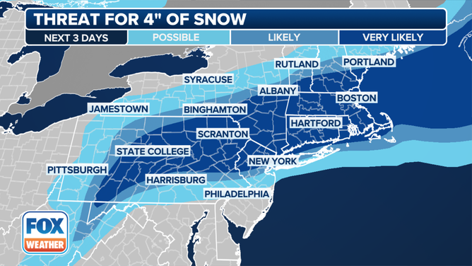
A graphic showing the threat of 4 inches of snow in the Northeast and New England. ( )
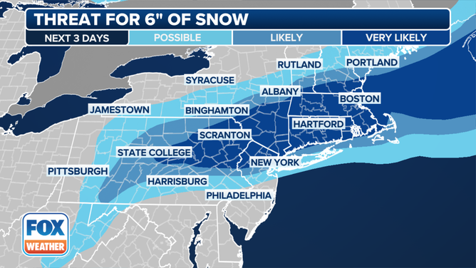
A graphic showing the threat of 6 inches of snow in the Northeast and New England. ( )
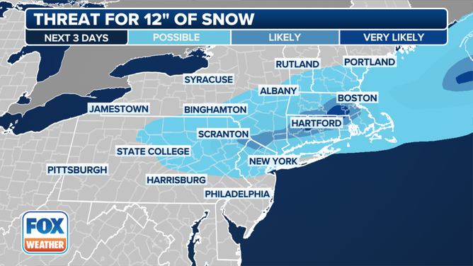
A graphic showing the threat of 12 inches of snow in the Northeast and New England. ( )


Visibility will also be limited to under a half-mile in the heaviest snow bands.
Up to a foot of snow with locally higher amounts is possible in parts of eastern Pennsylvania, southern New York and southern New England.
The FOX Forecast Center said the New York City tri-state area, northern New Jersey and northeastern Pennsylvania could see snowfall totals of 5-8 inches. The Boston area, eastern Connecticut and Rhode Island is at risk of seeing 8-12 inches of snow.
TRAVELING THIS WINTER? HERE'S WHAT TO KEEP IN YOUR CAR IN CASE YOU GET STUCK
Power outages, coastal flooding possible

A graphic showing coastal flood alerts in effect in the mid-Atlantic and New England.
(FOX Weather)
The FOX Forecast Center said power outages are also a concern due to the heavy, wet nature of the snow. As it accumulates, a heavier snow packed with water can add tremendous weight to tree limbs and power lines.
That, coupled with high wind gusts, could lead to snapped tree limbs and power lines, as well as possible damage to structures.
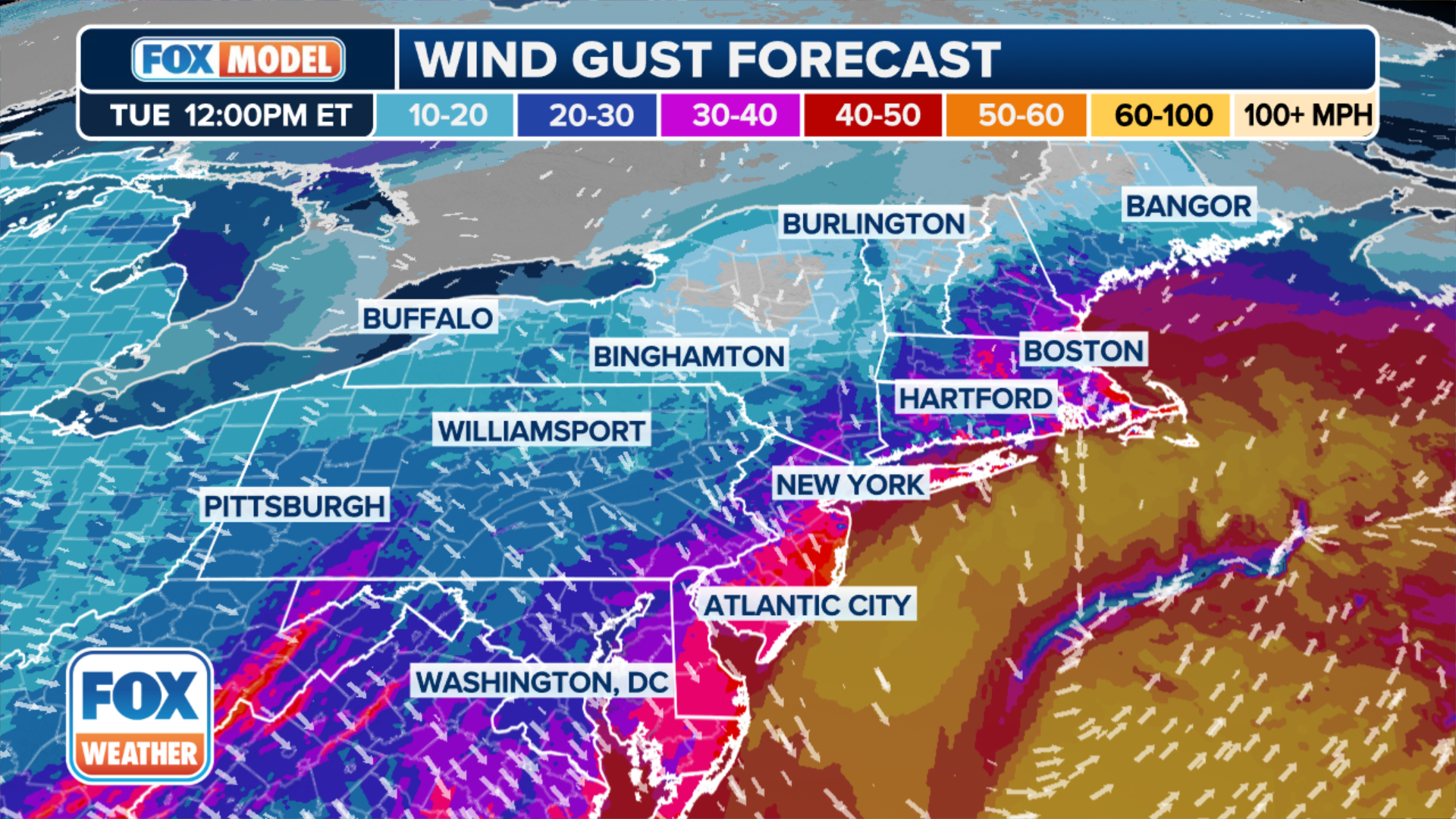
Winds could gust to 50 mph near the coast, which has prompted High Wind Warnings for coastal Massachusetts, including Cape Cod, Martha’s Vineyard and Nantucket.
(FOX Weather)
Farther inland, winds could gust up to 30 mph.
Coastal flooding is also a concern as the storm tracks to the south of Long Island and New England, which will create the strong northeasterly winds that will cause some moderate coastal flooding at high tide on Tuesday along portions of the New York and New England coasts.
One point on the map that meteorologists focus on in determining snowfall totals is the so-called "40/70 benchmark," located at 40 degrees north latitude and 70 degrees west longitude.
And just 50 miles to the east or west of that "sweet spot" can be the difference between an inch or two or a foot or more of snow.
As the storm approaches, computer forecast models will be able to better predict if the center of the storm's track will be near the 40/70 benchmark, ultimately raising a meteorologist's confidence in the forecast.


Comments
Post a Comment
Yorum ekle